8 newly geolocated videos from battle-scarred Khartoum
Tracking and mapping the conflict through geolocated combat videos
The principal warring parties in Sudan, the Rapid Support Forces (RSF) and the Sudan Armed Forces (SAF), continue to battle for control of a divided capital. They film videos bragging about controlling different areas, showing off captured or killed enemy soldiers, and insulting and trash-talking each other.
Often they seem oblivious or indifferent to the immense suffering of civilians, and the appalling destruction of the capital city in which they are fighting.
Sudan War Monitor is an independent open-source research project. Our work geolocating videos helps to contextualize visual information that is often shared for purposes of disinformation or self-aggrandizement. The sources of these videos are diverse: Facebook pages, influencer accounts on Twitter, private groups on Telegram, official or semi-official SAF and RSF accounts, etc. Below are eight videos recently geolocated from Khartoum and its sister city Omdurman.
⚠️ Content warning: These videos contain scenes of firearms, loud gunfire, destruction or damage of urban areas, killing (in video #6), and incendiary language.
1. Army troops in al-Fatihab
Coordinates: 15.5974805, 32.4612033. Geolocated by Muawia Yasin.
Uploaded September 25, this video shows SAF troops firing southward on Fatihab Road in Abuseid Block 8, which is 1.7 km southwest of the Engineers Corps base in Omdurman. Previously, we had assessed that this territory was controlled by the RSF, though near the limit of their control. This video therefore likely shows an attack by SAF into RSF territory, or a patrol into contested territory.
The army troops in this area, which has been besieged for several months, are survivors of a number of different units, as well as some troops recruited locally or smuggled into the area after the war began.
2. Combat north of Kober Bridge
Coordinates: 15.624643, 32.555710. Geolocated by Mustafa.
This video shows a mixed group of RSF infantry and thatchers (combat vehicles) attacking the eastern side of SAF-controlled territory in Kober.
The date is uncertain. The video was filmed from under an onramp leading to Kober Bridge, 700 meters north of the Nile. The video is a good example of why Kober Bridge is likely unusable by either side. On both sides of the Nile, the frontline runs roughly along the roads leading to the bridge (called Ebed Khatim Street on the Khartoum side). The large number of expended shells in the foreground indicates that this place has witnessed clashes before, some of which we previously geolocated.
The Houthi music in the clip is a legacy of the RSF’s time as mercenaries in Yemen. This kind of music is a favorite choice for their propaganda videos.
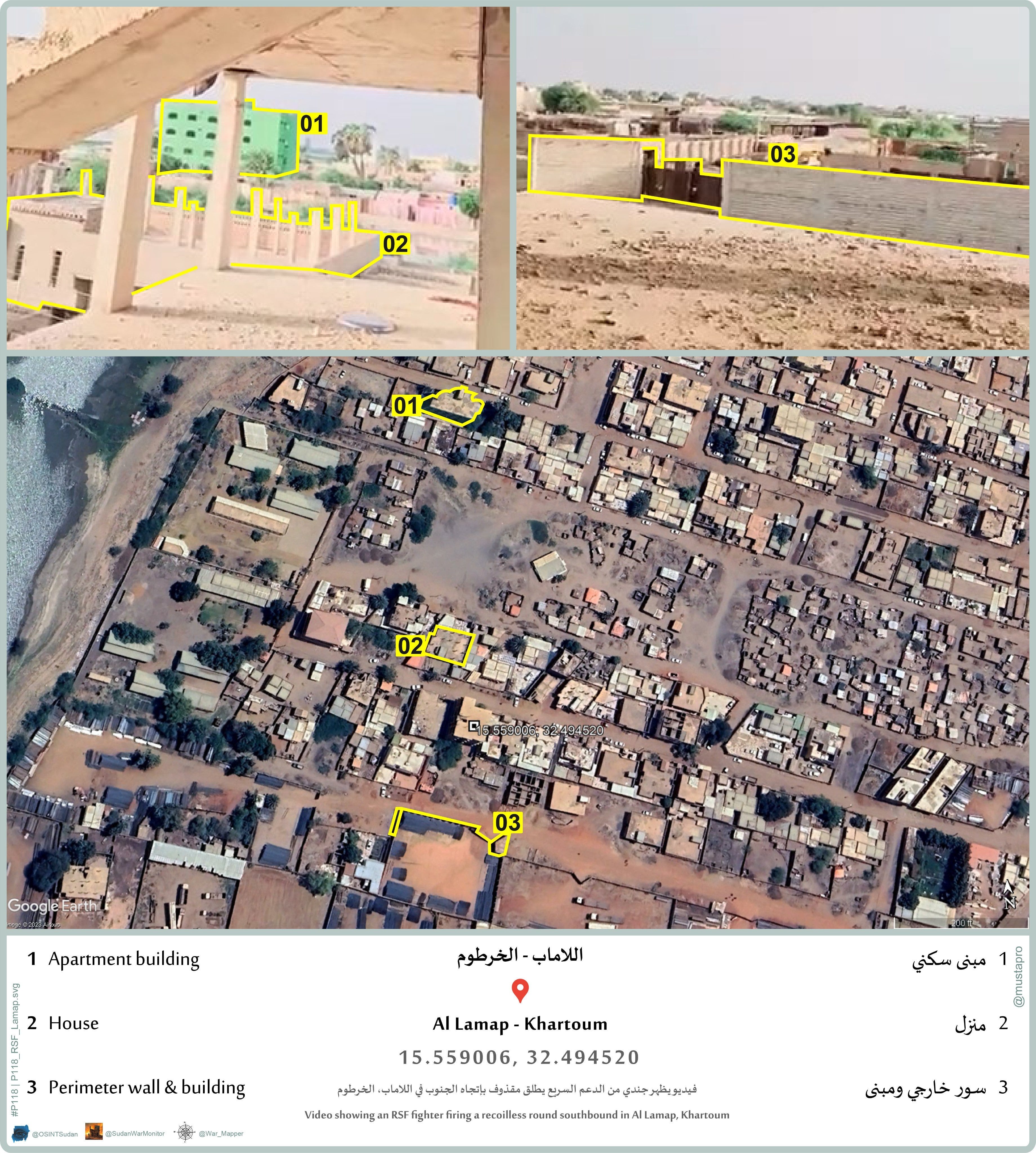
3. RSF firing recoilless gun in Al-Lamab
Coordinates: 15.658285 32.4699526. Geolocated by Mustafa.
This video was widely circulated on social media by pro-SAF accounts saying it showed an RSF fighter firing at a residential area—a talking point intended to blame the RSF for civilian casualties caused by shelling and bombings in Khartoum.
However, our analysis based on the geolocation and the estimated range of the weapon (Type 78 recoilless gun) showed instead that the target more likely was an area of warehouses and outdoor storage yards for construction materials in al-Lamab neighborhood in southwest Khartoum.
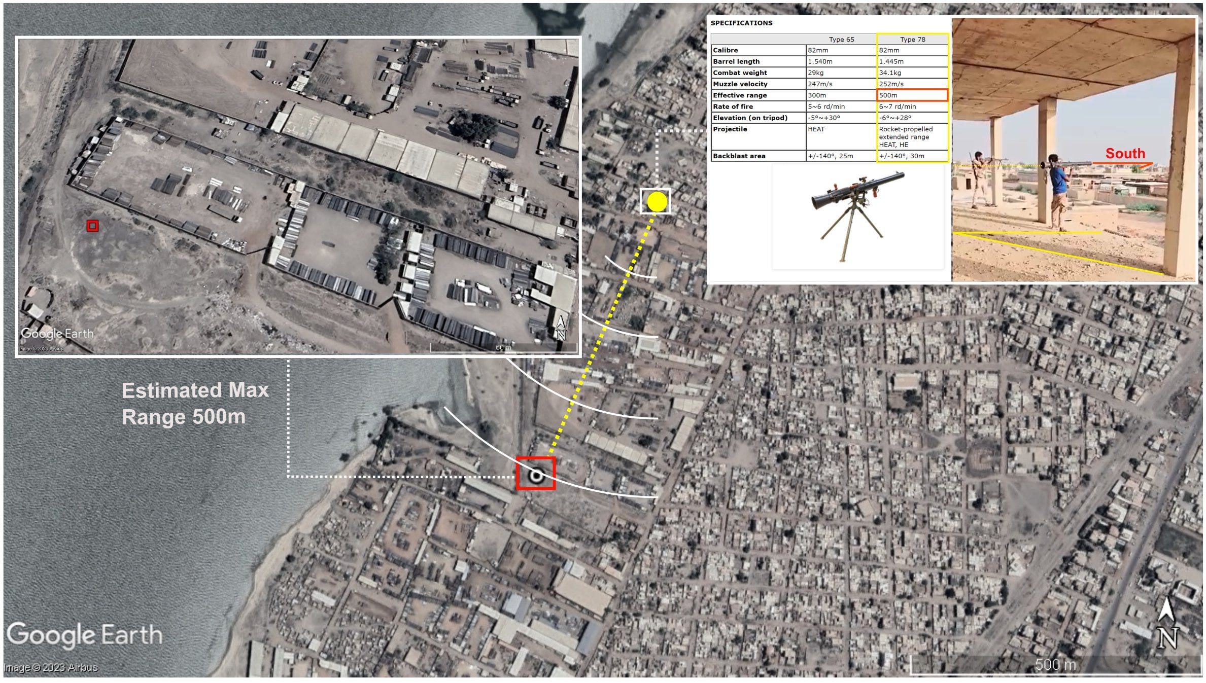
This is close to the contested Armored Corps base. We previously assessed that all of this area was controlled by RSF (both the gunman in this video and the target area). Therefore, we concluded that the video might show an RSF fighter firing a weapon for training purposes, or just to show off on social media.
Related coverage:

4. RSF raid north from Omdurman
Coordinates: 16.062029, 32.001805. Geolocated by يعقوب عبد الله دينق.
This video shows an RSF convoy on the road to Northern State, 60 km northwest of Omdurman. The video demonstrates that the RSF can move freely through northern parts of Khartoum State (apart from the better-guarded SAF supply route along the Nile). However, it doesn’t necessarily indicate that the RSF control this area. Rather, this is likely a raiding party seeking supplies or scouting for enemy logistics convoys and reinforcements. (Another possibility is that they are a group of reinforcements that were en route to Khartoum from Libya or Darfur).
RSF propagandists claimed this showed that they had advanced toward Dongola. However, the geolocation demonstrates that this is more than 400 km from Dongola.
Another video from the same location shows RSF troops speaking with traders, asking them how far is Khartoum, and how far is Dongola. From this conversation it almost seems as if they are lost.
Related coverage:

5. RSF convoy traveling on Salha Road
Coordinates: 15.454265, 32.401987. Geolocated by Mustafa.
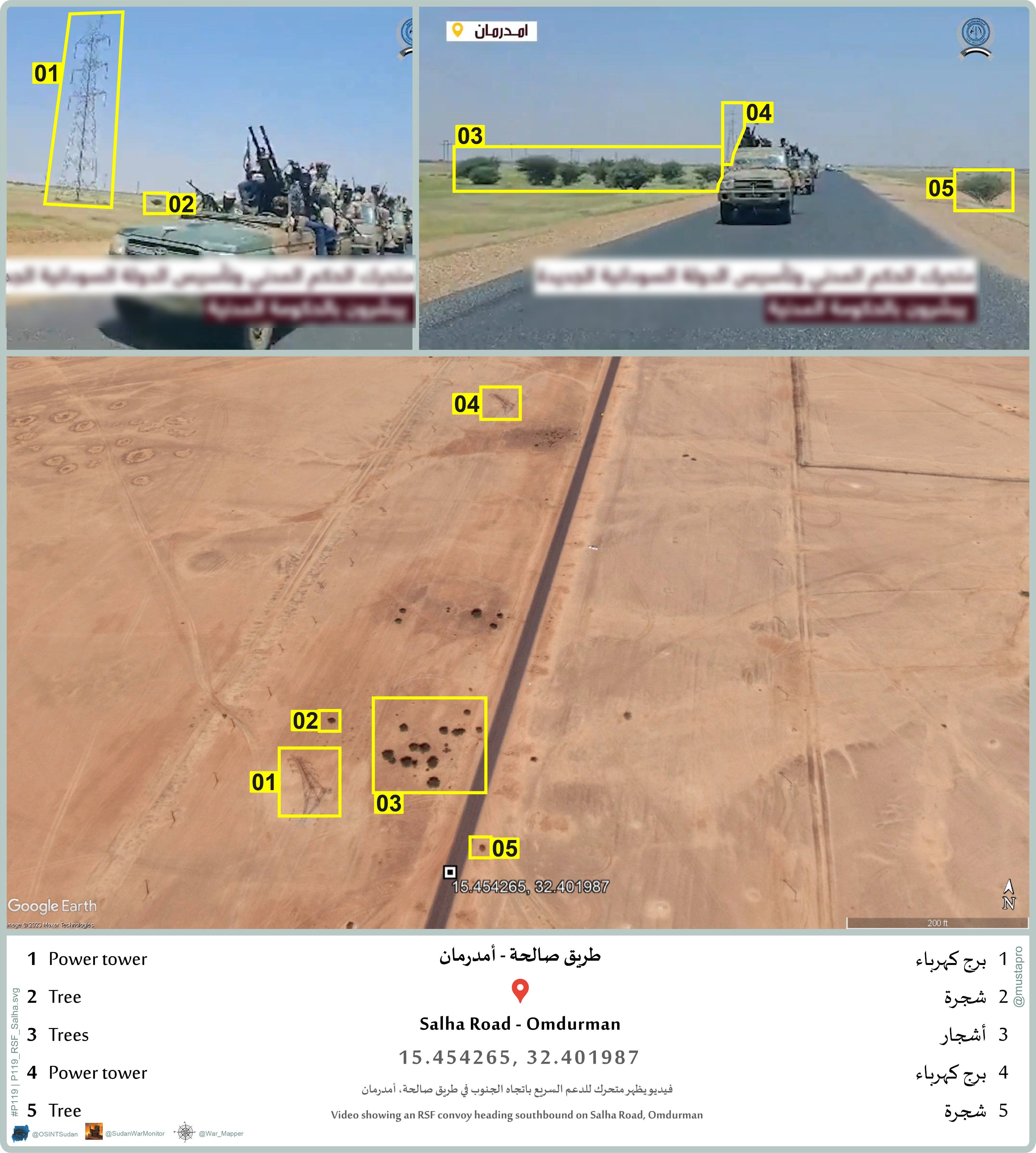
Posted by the official RSF Twitter account September 19, this video claims to show a force mobilizing toward Karari, the SAF-controlled northern part of Omdurman, but in fact it actually was filmed on the opposite side of Omdurman, on the Salha Road south of the city. This place is 4 km from a large RSF base pre-dating the war.
When this video began circulating, it angered many supporters of the 2018-2019 revolution, because at 1:00 they sing chants of that revolution, and throughout the video they claim to be fighting to bring democracy and civilian rule to Sudan.
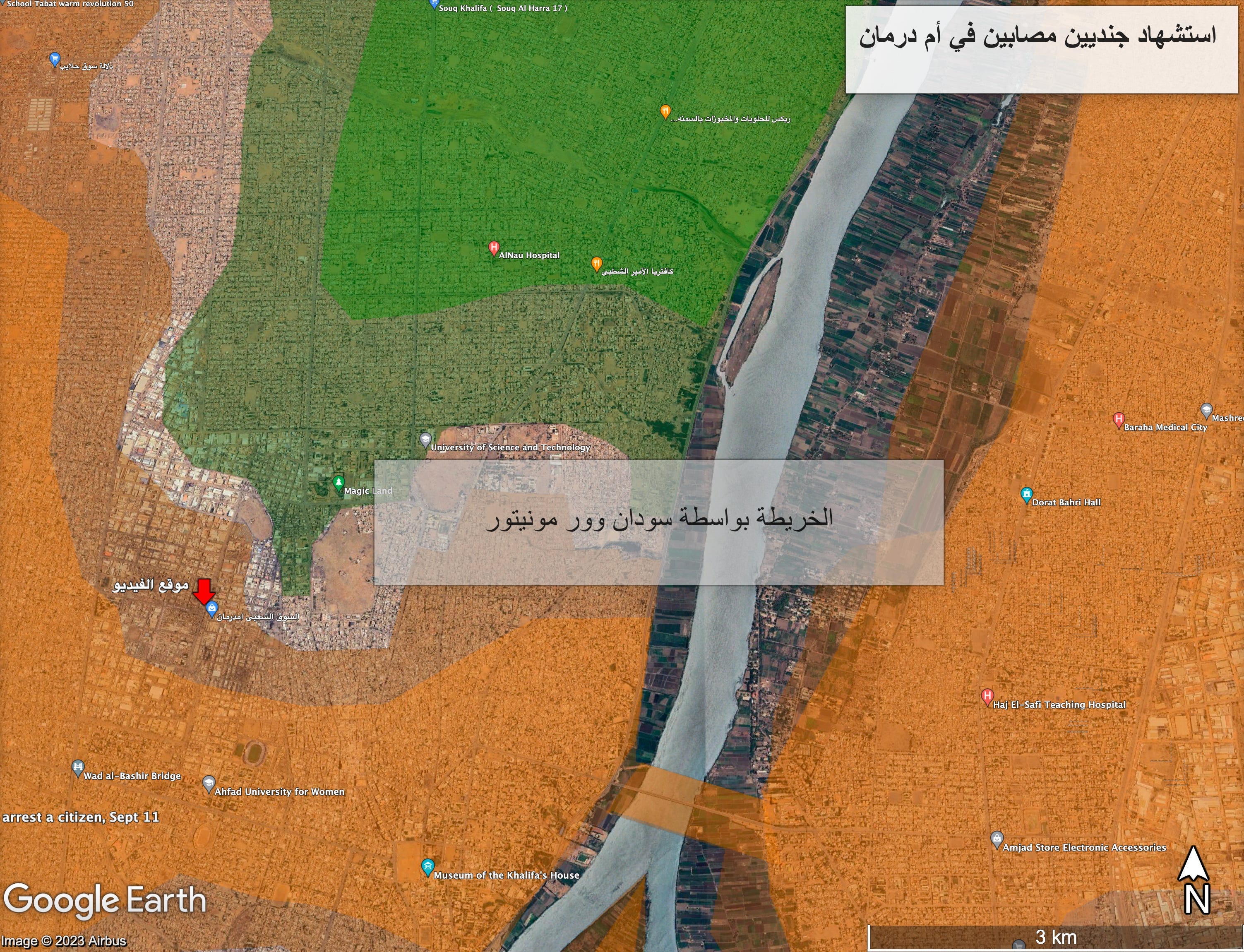
f Omdurman on an unknown date, according to geolocated video (very graphic; video will autoplay). The fighter is not wearing a uniform so he could belong to either RSF or a tribal militia allied with RSF, which dispatched fighters to Khartoum to support the RSF war effort. We shared this geolocation previously in an Arabic article and on our social media pages.
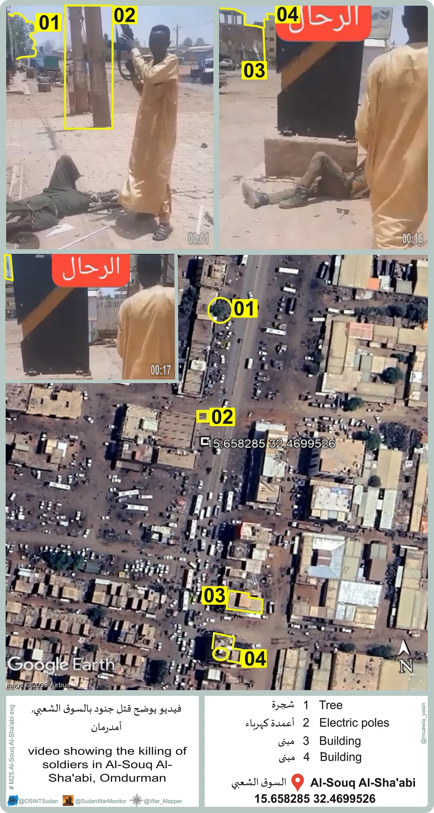
As to the location, it is very near where we located videos of other dead Sudan Armed Forces troops after fighting August 8. According to a military source, SAF have not carried out operations in this area for several weeks, suggesting that the RSF maintain control of most of the Popular Market, if not all, including the area seen in the video.
7. A drive along Nile Street
Coordinates: Begins at Nile Ribat University (15.614541, 32.5597397) and ends at the towers near Manshia Bridge (15.608908, 32.582433). Geolocated by خواجة مسكين.
The video was filmed by two RSF fighters in a civilian vehicle beginning just east of the frontline in the Burri neighborhood of Khartoum, then driving away from the frontline for a distance of 2.5 km. As they drive, the cameraman says (1:55) they made the video “so that nobody says the army controls the capital Khartoum or something like that. This is the capital Khartoum, capital of the (Rapid) Support, guardians of democracy… Burhan, there is no capital except Khartoum. The capital is Khartoum.”
This echoes a recorded message by the RSF commander-in-chief, Mohammad Hamdan Dagalo, who threatened September 14 that the RSF would establish a government in Khartoum, and would not tolerate the establishment of a second capital in Port Sudan, which is controlled by the army.
The person recording says this was filmed on September 19.
At 1:08, the video shows a roadblock consisting of three vehicles with their wheels removed, in front of the International Nile Club (15.613876, 32.566775). This is about 1.5 km from the nearest SAF troops. The RSF possibly built the roadblock as a way of restricting civilian movement, or as a secondary defensive position in case the army attempt to break out in this direction from the General Command.
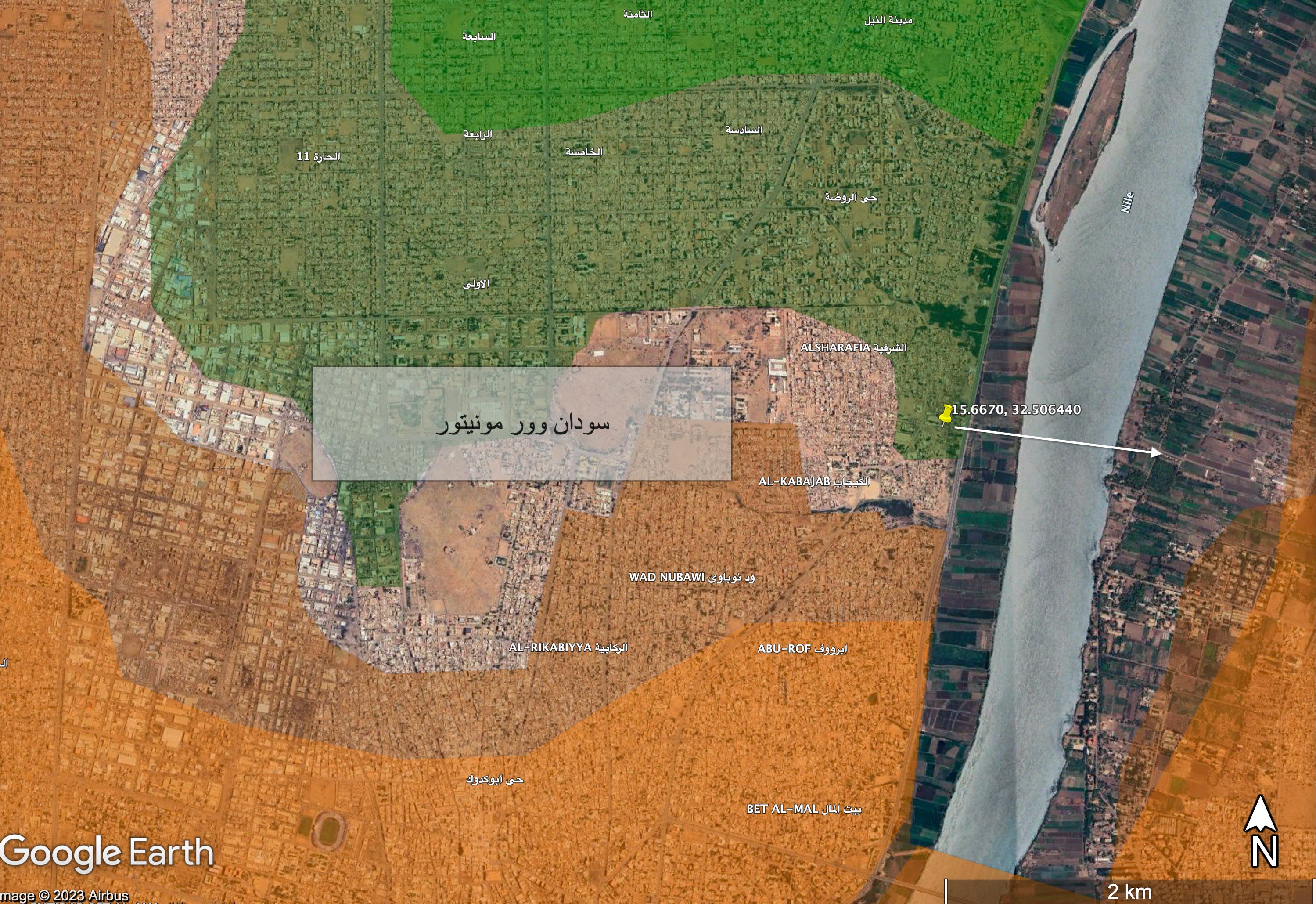
8. SAF near the frontline in Omdurman
Coordinates: 15.6670648, 32.5062070. Geolocated by Haytham.
Shared in a pro-SAF Facebook group on September 16, this video shows the Sudan Armed Forces firing a truck-mounted ZPU-2 autocannon in the al-Gamair neighborhood of Omdurman. This location basically is the frontline, just 200 meters north of where we previously assessed the limit of SAF control.
However, the soldiers are directing their fire east toward the river, not toward RSF positions to the south in Omdurman. This suggests that the video was filmed merely for propaganda purposes, and it does not depict actual combat. Nevertheless, the geolocation provides a new datapoint confirming SAF control in this area.