Tracking the RSF advance into Hai al-Matar
Three new geolocated videos from near General Command
The Rapid Support Forces (RSF) have recently taken control of more of Hai al-Matar, an upscale neighborhood next to the Sudan Armed Forces (SAF) headquarters in central Khartoum, according to videos from the area.
However, the limited amount of visual data and the RSF’s hit-and-run style of warfare make it difficult to assess the full extent of the paramilitary’s control. For purposes of our mapping, we still consider northern parts of the neighborhood contested.
It is unclear if the Sudan Armed Forces are defending this area house-to-house, or perhaps instead exerting partial control through occasional counter-attacks, patrols, and long-range strikes using mortars, drones, or artillery. Either way, the area is clearly contested and represents a key battleground in the fight for General Command.
The neighborhood is small, only about 25 hectares, and can be traversed by car in a matter of minutes. The above video was filmed roughly in the center of Hai al-Matar, and is represented on the map below by the eastern red pin. The video shows RSF infantry, a technical mounted with a ZPU auto-cannon, and an Ajban 440A armored car, during an RSF offensive in the area about a week ago.
That type of armored car is manufactured in the United Arab Emirates. They have been supplied to the RSF since at least 2022.
The video was posted September 24, 2023, but it may have been filmed a few days before that. Serious fighting began in this area September 16, and has continued.
Coordinates: 15.596723, 32.543966
Source: https://www.facebook.com/watch/?v=1786208635160885
Geolocation Proofs: Pending
Map of the Location: Red pins indicates the maximum confirmed extent of the RSF advance. The dotted red line indicates a hypothesized (though not confirmed) route of attack toward the perimeter of General Command.
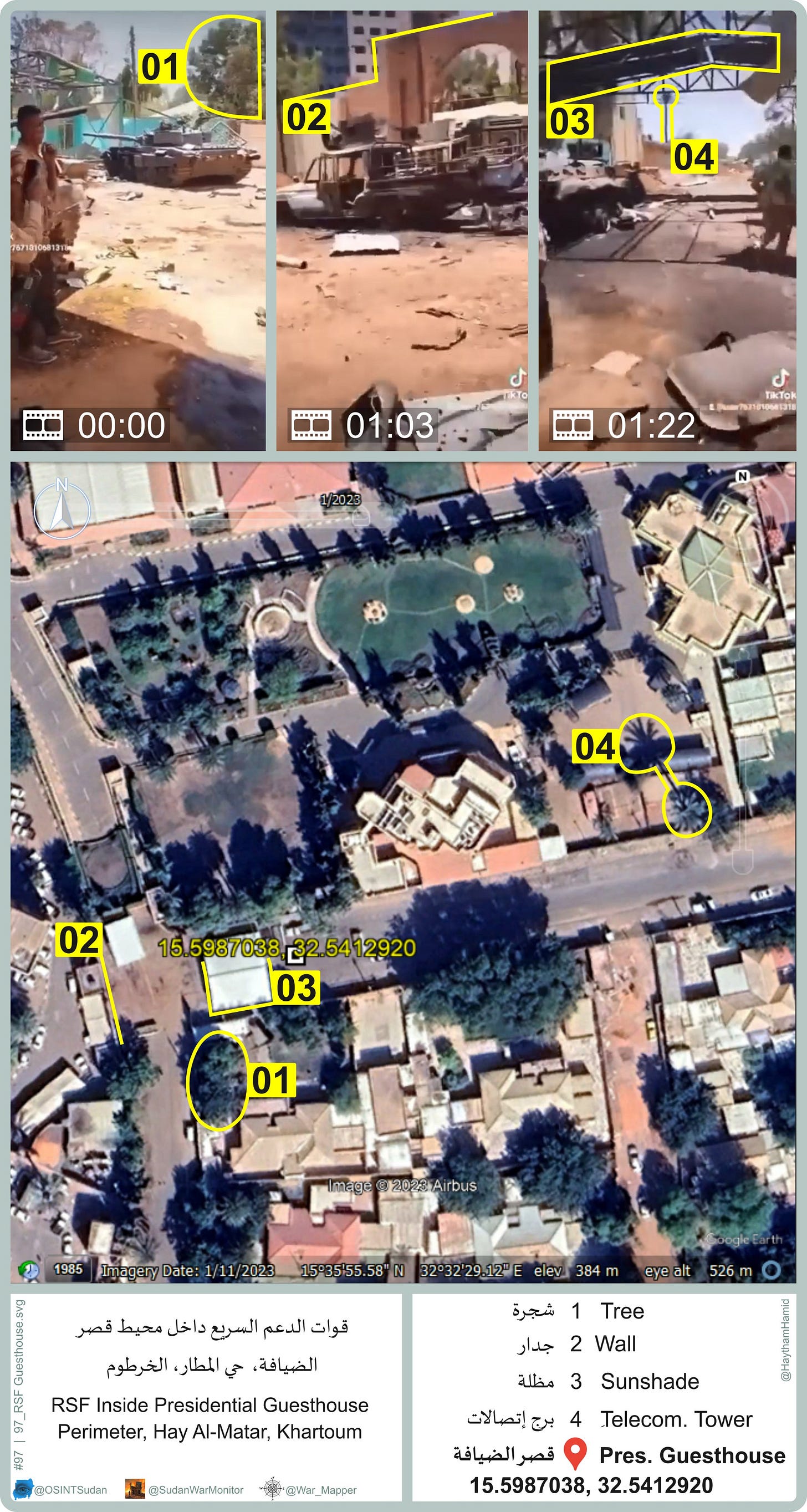
RSF outside the Presidential Guesthouse
Additionally, we geolocated another video from Hai al-Matar, filmed on September 16 or 17 at the gate of the presidential guesthouse (15.5987038, 32.5412920). The video shows wrecked vehicles and some bodies of SAF soldiers. The vehicles possibly were destroyed in fighting in April, but the dead bodies (blurred) are more recent.
Geolocation proofs:
Fighting at the Arab Development Bank
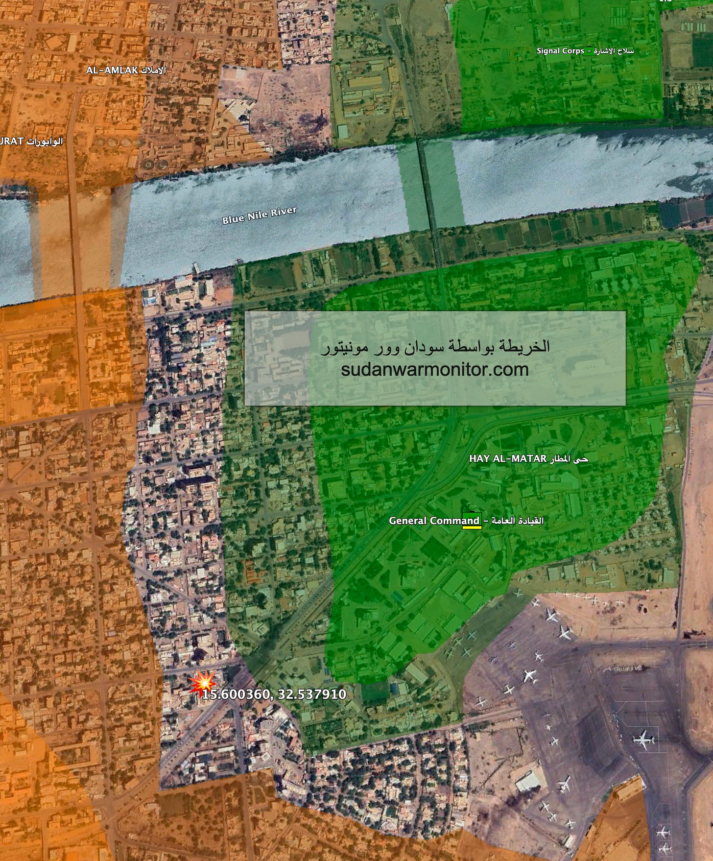
Finally, there has been fighting nearby at the Arab Bank for Economic Development in Africa (15.600360, 32.537910), which is only a half kilometer from Hai al-Matar. The video shows SAF soldiers on the bank’s grounds, shooting at the upper floors of National Records Office adjacent to the bank to the west.
This means that the exact frontline in this area, at least when this was filmed, was the street between the Bank and the National Records Office.
One of the soldiers is wearing a t-shirt with the logo of the bank (0:31, 1:18), suggesting that SAF have been occupying the building for some time, including offices or storehouses where the soldier may have found this item.
The Arab Development Bank is at the western edge of the besieged General Command area in central Khartoum. It is a tall building that commands a view of the road in front of General Command, so it is an important defensive position.
The fire-damaged military intelligence headquarters, located 200 meters away, is visible at 1:06. Here is a map of where the video was filmed. Note that the lines of control were drawn prior to the geolocation of this video, and the video approximately confirms the correctness of the frontline that we had drawn. Uncolored areas represent contested areas, green are controlled by SAF, and orange by RSF.


